
Trace a Monroe Street by Address
For a current Monroe address-record question, begin with the address rather than a person’s name. The public BS&A property and tax search can connect an address to a parcel and the assessed owner. The Monroe County Parcel Viewer supplies the map setting, including parcel boundaries, municipality lines, ZIP layers, and centerlines. Ownership is not the same as occupancy. That distinction matters when an owner receives tax mail elsewhere or a parcel contains more than one private household.
- Enter the physical address in BS&A, then save the parcel number and the displayed legal description.
- Open the parcel viewer, locate the street segment, and click the target parcel to compare it with the map and nearby lots.
- Use the assessed owner and an approximate date in the deed index. The county says staff cannot search deed ownership by street address.
- Read the instrument’s grantor, grantee, date, and legal description before treating it as part of the same property chain.
- Use a voter-record request or historic reverse directory only for the limited residence evidence each source actually provides.
That sequence keeps the Monroe street-by-street search focused on a defensible address trail. The Monroe street directory is strongest when the parcel and legal description remain attached to each result. A name found in a recorded deed may be an owner, trustee, estate representative, or business entity. A name in a historical directory may be a household head or business listing. Compare dates and identifiers before joining them.
Search a Monroe Street in BS&A
BS&A is Monroe’s practical address-to-parcel route. Its documented modes separate detailed records, current tax records, delinquent tax records, assessing records, and payment routes. Address search accepts a street number or range with a street or full address. When a street spelling or number format does not resolve, use the parcel number from GIS or the owner or taxpayer name. The name option is an owner or taxpayer search, not a search of every Monroe resident at the location.
| Field/control | Type | Required | Search/display detail |
|---|---|---|---|
| Address | text | not stated | Street number/range and street/full address; current portal label. |
| Name | text | not stated | Owner/taxpayer-name search; last name preferred in BS&A documentation. |
| Parcel Number | text | not stated | Local parcel identifier. |
| Search scope | link/dropdown | optional | All Records, Assessing, Tax in documented BS&A form. |
| Detailed Record Search | link/tab | - | Full parcel detail route. |
| Current Tax Search | link/tab | - | Current tax route. |
| Delinquent Tax Search | link/tab | - | Delinquent tax route. |
| Assessing Search | link/tab | - | Assessment route. |
| Pay a Bill / Pay delinquent taxes | link | - | Payment, not resident search. |
| Advanced address search | control | optional | Further address narrowing; the exact Monroe rendering was not located. |
The research did not confirm every live label or all advanced controls on the Monroe entry. Treat the table as the documented starting set, then check the form shown at the time of search. For card-specific interpretation, the City of Monroe Assessor handles parcel information, assessment forms, sales information, and value questions.
Note: A BS&A result supports an ownership and tax inquiry, but it does not establish that every person at the situs address lives there.
Use Monroe Parcel Maps by Street
The county viewer lets a Monroe address search move from a typed address to the geography around it. Turn on parcel boundaries and centerlines, then note the parcel ID and legal description from the target polygon. Municipality and ZIP layers help prevent a postal city label from being mistaken for a city-limit finding. Roads, buildings, water, parks, railroads, and topography provide context, but they do not identify occupants.
Click nearby polygons one at a time. A road, alley, river, railroad, empty parcel, or jurisdiction line can make properties look close without making them part of one legal block. That map check keeps a Monroe street directory result tied to the right geography. The viewer’s assessment information is updated biannually and is intended for spatial browsing, not for a legal boundary survey. Contact the local assessor or county clerk for a boundary question that needs an official answer.
Monroe Street Directory Record Sources
Address-keyed sources each answer a narrow Monroe address-record question. The parcel record supplies ownership and tax context. The deed index supplies recorded transfers. Building and zoning files can date work at an address. Voter administration and historic directories have different limits. Use the parcel number and legal description to keep the sources tied to the same real property rather than relying on a street string alone.
| Address record | Monroe custodian | Evidence along a street | Access path |
|---|---|---|---|
| BS&A parcel and tax record | Local assessor and tax system | Owner or taxpayer, parcel, situs and mailing context, tax and sales fields | Public address, name, or parcel search |
| County GIS parcel layer | Monroe County | Parcel polygons, street orientation, ZIP and municipal context | Public ArcGIS viewer |
| Recorded instruments | Clerk/Register of Deeds | Grantor, grantee, instrument, recording details, legal-description continuity | Fidlar search, office counter, and historical repositories |
| Building and zoning file | City Building Division and Planning | Address, applicant or owner, work, inspection, certificate, or site-plan timeline | Counter or narrow city FOIA request |
| Voter registration record | Clerks and Michigan Bureau of Elections | Limited registration and address evidence for a lawful individual or file request | MVIC or QVF request, with protected fields withheld |
| Historic reverse directory | MCLS, GSMC, and Library of Michigan | Past street or house-number listing, subject to the volume’s scope | Print, microfilm, catalog, or licensed/digitized route |
Monroe County Equalization also maintains computerized assessment rolls, tax maps, property descriptions, and equalization reports. It is a county review function, not a substitute for the local assessor’s parcel decision. For current or delinquent tax routing, use the BS&A modes or the county’s Equalization and Treasurer contacts.
Monroe Deed Searches Need a Name
Deed work is a key part of a Monroe address-record trail, but the county’s practical rule is name first. Fidlar Direct Search offers Party Name, dates, document number, document types, Book, Page, Reference Number, plus Address, Subdivision, Parcel, Municipality, and Tract tabs. The Register of Deeds FAQ still directs researchers to bring a grantor or grantee name and an approximate year because staff cannot search ownership by street address.
Use the property record to obtain the current owner and the parcel’s legal identity. Then use the person or entity as a grantee search, inspect the resulting instrument, and search the seller as a prior grantee. A legal description, lot and block, parcel, or predecessor tract is the check against joining a same-name party to the wrong Monroe property.
Start with the county’s Fidlar Direct Search when checking the indexed options shown here.
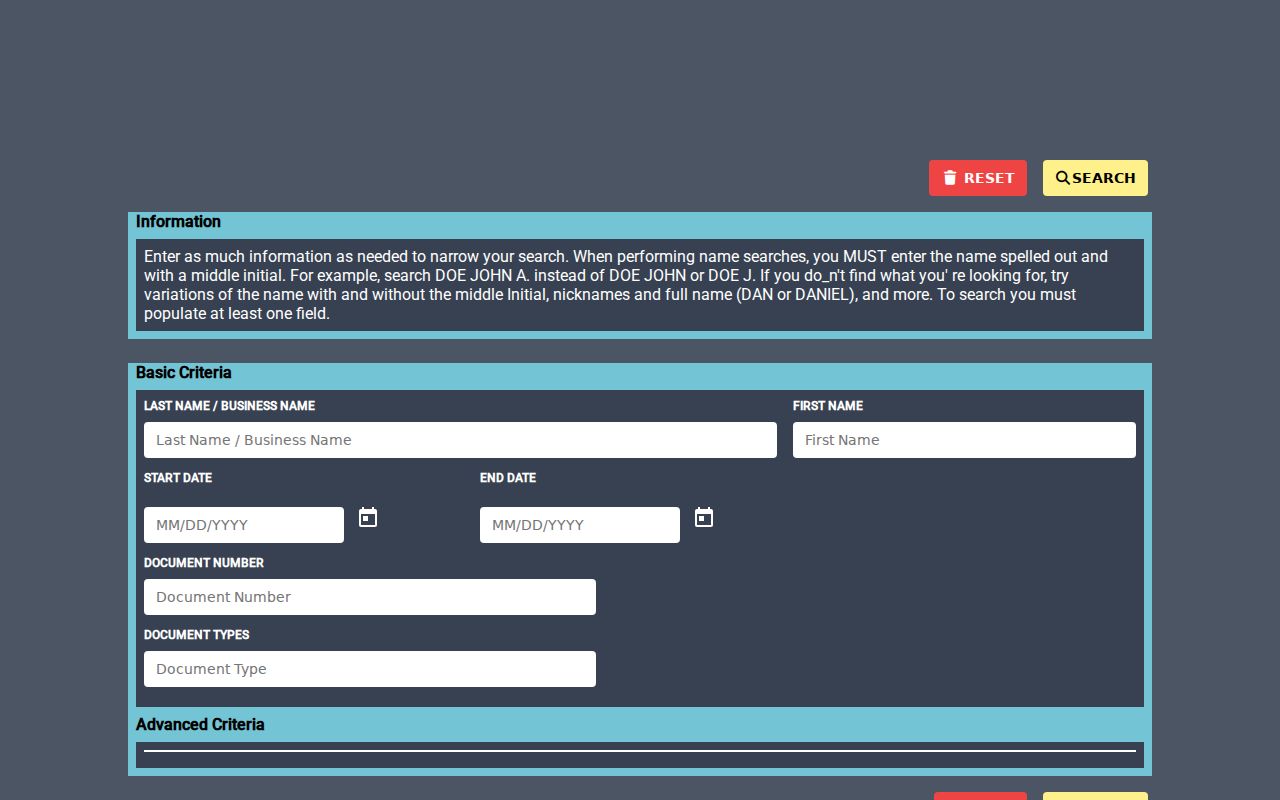
The available tabs can help narrow a recorded-instrument search, but an address-tab result still needs a parcel or legal-description check before it is treated as a match.
Monroe Street Legal Description Clues
A street address can change format, while the legal description is often the steadier bridge between Monroe parcel, assessment, deed, and historic-map records. Older properties along the River Raisin can carry French Claims or private-claim descriptions. Those narrow strips do not follow the simple rectangular section-grid pattern many researchers expect. When a historic address fails, check the parcel, lot and block, Book/Page, or claim description rather than repeating the same street query.
- Parcel
- An assessment and GIS identifier for a defined piece of property.
- Situs address
- The physical location used for mapping, assessment, permits, zoning, and local geography.
- Mailing address
- The destination for tax or owner correspondence. It may differ from the Monroe situs and is not proof of residence.
- Legal description
- The title identity of land, such as lot and block, subdivision, metes and bounds, or a French Claim.
- Plat
- A recorded map or plan that can connect a subdivision’s lots and blocks to the property description.
- Criss-cross directory
- A reverse-style directory arranged by street and house number instead of by personal name.
The Monroe address record may also hold a homestead or PRE classification. It can support an owner-occupancy inference, but it remains tax evidence, not proof that a particular person is currently present.
Voter Evidence on a Monroe Street
The Michigan Voter Information Center is an individual voter-information route, not a street-wide roster. It can provide registration-status and election-use information for a matched individual. A wider request goes through the Qualified Voter File process, where geography can be county, jurisdiction, district, school, ward, precinct, or related choices. No simple public ZIP-wide or street-wide resident export was confirmed.
Michigan voter-registration records are public through FOIA, with important redactions. Driver-license or state-ID numbers, month and day of birth, phone, email, signatures, receiving-office information, and other protected fields are not public. The QVF data-request form describes the available geography and delivery choices. It does not turn registration data into proof that every adult at a Monroe address is a voter or that an unlisted person is absent.
Monroe Permit Files by Address
For physical changes on a Monroe street, the City Building Division can supply a different date trail. Its work includes building, plumbing, mechanical, electrical, sign, zoning-compliance, temporary-use, contractor-registration, certificate-of-occupancy, and inspection records. A preserved file may identify an address, applicant or owner, work description, permit or inspection date, and certificate information. The online forms page is not a verified public archive searchable by address.
Call the Building Division at 734-384-9186 to ask for an existing address record, or make a narrow city FOIA request for a defined address and period. Planning and Zoning packets can add site-plan or board-decision context. Historic District Commission files can be especially useful for an older property because the city’s 1978 survey and 1998 historic districts document preservation context.
Note: A permit or inspection record documents a property event, not every occupant, visitor, or private household associated with the location.
Historic Monroe Street Directory Listings
Older Monroe street-listing evidence belongs at the library and historical collections rather than in a current parcel lookup. The Monroe County Library System’s Ellis Library genealogy collection includes city directories, plat maps, land records, newspapers, probate material, family histories, oral histories, and microfilm or electronic research routes. The Genealogical Society of Monroe County and the Library of Michigan also provide catalog and directory paths.
In a reverse or criss-cross volume, search the street alphabetically and then the house number. First check whether the volume lists owners, occupants, businesses, or only a household head. Monroe materials include a linked 1860 directory and later cataloged 1916 and selected 1946 through 1960 runs, but a complete verified reverse-directory run was not located. For a person found in a past volume, the Monroe city directories collection provides the historical-collection angle without confusing it with today’s address records.
Monroe Street Deed Access Dates
The county’s current online name index begins January 1, 1981. County information also describes Laredo remote and in-house records access from 1976. Those dates describe access layers, not a promise that every instrument image is freely available or that older records do not exist. Older deed indexes and books remain a county and historical-repository route. The county’s preservation materials describe deed indexes from 1807 to 1928 and deed books from 1807 to 1850, while Library of Michigan guidance identifies Deed Books A, B, and C from 1806 to 1818.
Use the Monroe County Deeds Search page to compare Direct Search with the remote-access choices and current notices.
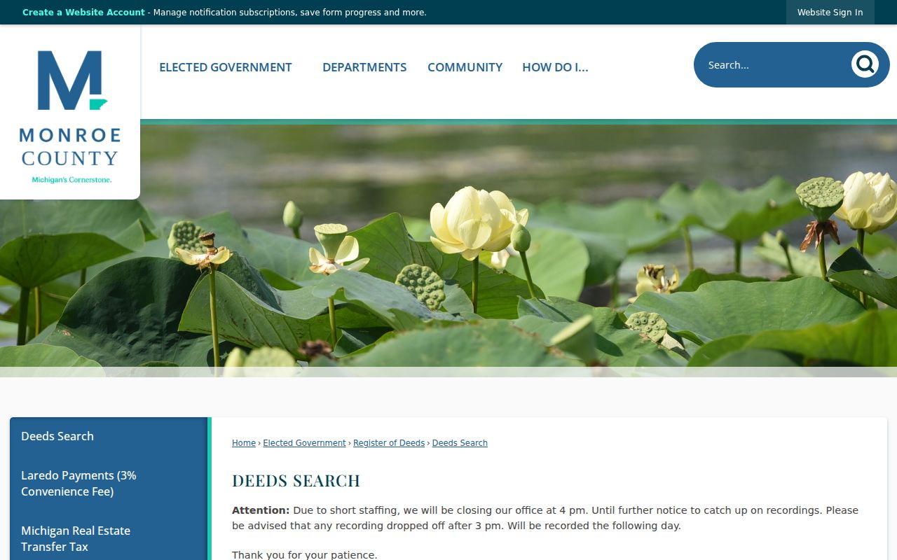
A missing online image is an access question, not proof that the deed trail ended. The Register of Deeds counter, MCLS, the Library of Michigan, Archives of Michigan, and a focused FOIA request remain useful fallback channels when the needed record is outside the visible online result.
Monroe Street Record Fallbacks
When a Monroe address search does not resolve online, narrow the question before contacting an office. Give the assessor an address or parcel issue. Give the Register of Deeds a grantor or grantee and approximate year. Give the city a defined permit, inspection, zoning, or historic-file request. The county FOIA route is for existing non-posted records, not a replacement for a certified vital record or a paid deed image.
For older material, use MCLS for printed or microfilm directories, plat maps, newspapers, and probate references. The Library of Michigan’s Monroe County guide and the Archives of Michigan identify older deed, court, tax, naturalization, probate, and voter-related record groups. An archive listing is not a claim that an item is digitized, so ask about the exact volume, reel, or access process.
Privacy Limits for Monroe Street Directory Records
A Monroe address-record search cannot produce a public list of every private occupant, household member, visitor, utility customer, delivery recipient, or driver-record address. A parcel card may show a title or tax name, and a historical volume may show a dated household listing, but neither fills those private gaps. Michigan’s Address Confidentiality Program can also replace or shield an eligible participant’s ordinary public address. Do not try to reconstruct a protected address from other records.
The right correction path is the source custodian: the City Assessor for parcel data, Register of Deeds for recording or index questions, city staff for municipal files, and the Bureau of Elections or local clerk for voter records. Record an exact parcel, instrument, or request identifier when reporting an error.
Monroe Address Geography Can Differ
A Monroe mailing city and ZIP do not by themselves establish City of Monroe jurisdiction. ZIPs 48161 and 48162 serve the city as well as portions of nearby townships. Confirm the parcel’s municipality layer, legal description, and local assessor before treating the same street name as a city record. That small check avoids sending a records question to the wrong office.
Keep the physical situs, mailing address, postal ZIP, parcel number, and legal description in separate notes. The parcel number and legal description are particularly useful when a street string changes punctuation, direction, suffix, or older spelling. They are also the bridge from a modern Monroe address to historic plat, atlas, deed, and directory records.
Note: A consistent parcel and legal description are stronger cross-era keys than a mailing city label or an assumed city-limit boundary.